The Silver Comet Trail
Looking for information about the Silver Comet Trail? This page should help! The Silver Comet Trail is a public paved running, biking and skating path that starts near South Cobb Drive (it is easy to find; on the west side of Atlanta, just off I-285, about 4 miles south of Cobb Parkway / Cumberland Mall area). You will find a map at the bottom of this page. It was made by tearing up an old railroad line and paving it. Cobb's section of the Silver Comet Trail is a scenic 12.8 mile paved multi-use trail that begins in Smyrna and travels west through southern parts of the County. The trail follows the abandoned railroad line once traveled by the Silver Comet passenger train.
 |
The Silver Comet train was
introduced by the Seaboard Air Line Railroad in 1947. Originally fitted with an
observation car and sleep lounge cars, it carried passengers through southern
cities like Atlanta and Birmingham to destinations in the north such as New
York, Philadelphia, and Washington.
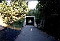
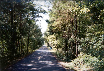
As passengers traveled across the countryside, they were treated to a variety of
scenic vistas along the way. Today the rail line has been converted to a
multi-use trail that is designed for use by all. Casual walkers, hikers,
joggers, bicyclists, inline skaters and people with disabilities can all use the
trail and enjoy some of the same sights once reserved for the train's
passengers.
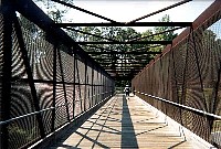
Traversing six trestles and bridges, the trail offers spectacular views and
direct access to one of Cobb's newest recreation areas, Heritage Park. The
entire length of the trail is currently open with 6.9 miles paved and the
remainder to be completed by fall 2000.
 |
 |
 |
The trail will ultimately extend 57 miles through Cobb, Paulding, and Polk
counties and current plans call for this section to link with other trails and
allow direct access between Atlanta and Birmingham.
Four Trailheads have been constructed offering parking, restrooms, water
fountains and related amenities. The trailheads are an excellent place to access
the trail and begin your adventure. They are open from dawn to dusk. For
individuals who reside close to the trail, it can also be accessed at numerous
cross streets. Nearby residents are encouraged to walk or cycle to one of
these locations.
Although trail security is enhanced by a special bicycle unit of the Cobb County
Police Department, users are encouraged to use the buddy system and ride, walk
or jog in pairs or groups.
For more information on the Silver Comet Trail, you may call Cobb County Parks,
Recreation and Cultural Affairs Department at (770) 528-8840.
In Cobb & Paulding Counties construction is complete on the Silver Comet Trail. Many sections in Polk county are now complete. Thanks go to many people including Senator Nathan Dean and Alicia Soriano but most of all to the PATH foundation. The once railroad line has become a first rate trail, although paved. Ultimately, it will extend 57 miles! Starting at Mavell Road It will connect Powder Springs, Dallas, Rockmart, Cedartown , and end at the Alabama border. This is an expensive but exciting proposition, $13.5 million.
Parking: Many places along the trial including; the trail head at Mavell Rd., Fontaine Rd. at East-West Connector, Cooper Lake Rd. north at Derby Lane (etc.).
- Cobb County's web page with information about the trails in Cobb
- TrailExpress.com GREAT NEW SITE (Super map and table of access points)
- THE SILVER COMET 10K Run & Family Walk Home Page
- Rails-To-Trails Conservancy
- This website explains the origin of the name, and the history of the Silver Comet train.
- There ius even a bike repair shop (and snacks) right on the trail. Here is their website.
- More facts are at this Tripod site (be warned, you will be bombarded with pop-up ads)
- Wildhorse Creek Trail - another trail nearby (again, this website has annoying popup ads)
- And here is the best map I can find - Cobb took down other good maps they had!
 |
|